As June comes to a close, the focus of severe weather is moving north.
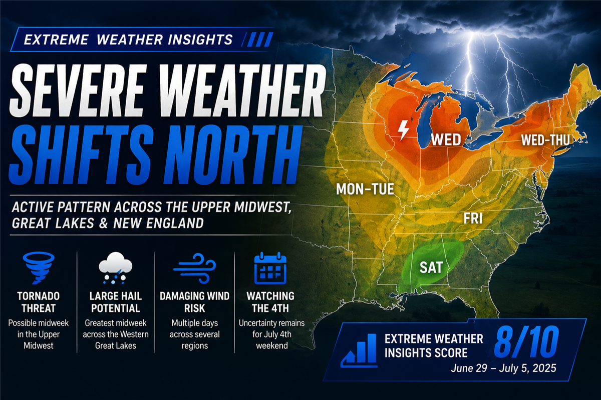
After several weeks dominated by the High Plains, this week's Extreme Weather Insights forecast highlights an active pattern across the Upper Midwest, western Great Lakes, and parts of New England. With an Extreme Weather Insights Score of 8/10, multiple rounds of severe storms are expected between June 29 and July 5, bringing threats of large hail, damaging winds, and tornadoes to several populated markets.
For roofing contractors, restoration companies, insurance professionals, and storm response teams, the middle of the week presents the greatest opportunity.
Last Week's Forecast Played Out as Expected
Last week's forecast proved to be one of the most accurate of the season.
The greatest concentration of severe weather developed exactly where anticipated, stretching from the Texas Panhandle through northeast Colorado, western Nebraska, the Dakotas, and into portions of the Carolinas and Virginia.
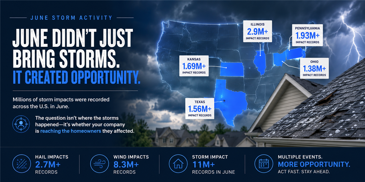
More than 1,000 damaging wind reports were recorded nationwide once again, continuing one of the strongest wind-driven severe weather seasons in recent memory.
Large hail remained concentrated across the central High Plains, with numerous reports of hail exceeding two inches in diameter across:
Northeast Colorado
Western Nebraska
The Texas Panhandle
The Dakotas
Eastern Montana
While hail activity continues to track below the 15-year average, the consistency of damaging wind events has created significant opportunities for contractors responding to storm damage across a much broader geographic footprint.
Monday Begins with the Northern Plains
The week opens with an active severe weather setup already underway.
Storms across the Dakotas are capable of producing ping pong ball-sized hail and wind gusts approaching 80 mph before shifting into Minnesota.
Throughout Monday, attention shifts toward:
Southern South Dakota
Northwest Iowa
Nebraska
The Twin Cities metro
Early storms are expected to produce the greatest hail threat before evolving into a larger damaging wind event later in the day.
Tuesday Brings the Great Lakes into Focus
By Tuesday, the same storm complex pushes east.
Northern Wisconsin and Michigan's Upper Peninsula become the primary areas for large hail and damaging winds, while portions of eastern Minnesota remain close enough to the storm track to warrant continued monitoring.
Although widespread outbreaks are not expected Tuesday, conditions continue building toward a more significant event.
Wednesday Is the Week's Biggest Day
Wednesday appears to be the highest-impact day of the forecast.
The western Great Lakes region, particularly around the Twin Cities, could experience one of the strongest severe weather setups of the season.
Forecasters are monitoring the potential for:
Large hail exceeding three inches
Damaging straight-line winds
Isolated tornadoes
Long-track severe thunderstorms
At the same time, New England enters the severe weather picture, with all hazards—including hail, damaging winds, and tornadoes—possible across several northeastern markets.
For contractors operating in Minnesota, Wisconsin, or New England, Wednesday is the day to watch most closely.
Additional Activity Through the Holiday Weekend
The pattern remains active through the end of the workweek.
Thursday keeps hail potential across the eastern Dakotas, northern Nebraska, and portions of the High Plains while maintaining severe weather risks across New England.
Friday returns attention to the Upper Midwest, including the Twin Cities and surrounding areas, as another round of severe storms develops.
Forecast confidence decreases somewhat heading into the Fourth of July weekend, but current guidance suggests the primary storm boundary may extend across:
Southern Minnesota
Wisconsin
Northern Illinois
Northeast Iowa
Storm timing and exact locations will likely shift over the coming days, but these regions currently appear to have the highest potential for Independence Day severe weather.
By Sunday, much of the country turns hot and humid, but a lack of stronger upper-level wind support should limit widespread severe storm development.
What Roofing and Restoration Companies Should Watch
This week's severe weather pattern shifts away from the southern High Plains and into more densely populated markets.
Key areas to monitor include:
Monday: South Dakota, Nebraska, northwest Iowa, Twin Cities
Tuesday: Northern Wisconsin and Michigan's Upper Peninsula
Wednesday: Twin Cities, western Great Lakes, New England
Thursday: Eastern Dakotas, northern Nebraska, New England
Friday: Upper Midwest and northern Plains
Saturday: Southern Minnesota, Wisconsin, northern Illinois, northeast Iowa
Bottom Line
The first week of July is shaping up to be one of the more active stretches of the summer, particularly across the Upper Midwest and western Great Lakes.
With multiple days of large hail, damaging winds, and tornado potential forecast across populated markets, contractors who monitor storm activity closely will be well positioned to respond quickly as opportunities develop.
As always, continue monitoring the latest storm swaths and forecast updates throughout the week, especially as Independence Day approaches and forecast details become more refined.
Tags
Subscribe to Predictive Sales AI, LLC's Blog


Comments